
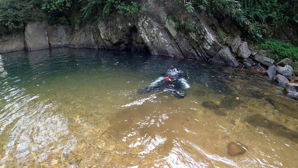
Rangala Natural Pool is situated in Elagolla, south of the Knuckles Forest Reserve. It is a natural fresh water reservoir that has formed as a water collection point and is a small part of the Kota Ganga. The natural pool is situated by the Kota Ganga Bridge.
As an Underwater Explorer specialising in exploring and documenting Ship Wrecks and Underwater Caves in Sri Lanka, the author of this report (Dharshana Jayawardena and Nipun Samintha) took a keen interest of exploring the Rangala Natural Pool as there could be a possibility of an underwater cave system. After successfully exploring the Nil Diya Pokuna underwater Cave in Karandagolla, Ella, and mapping it, we wanted to identify other underwater cave systems in Sri Lanka.
To seek permission for the exploration of Rangala Natural Pool, on 30th of January 2021, The authors of this report contacted Officer In Charge, IP Rangajeewa Rajapakse, on an introduction provided to him by his(Dharshana Jayawardena) uncle, former SSP Hatton Division, Ravi Chandrasinghe. Upon discussing the exploration request with IP Rangajeewa, he informed the authors that several swimmers had drowned in the pool and it would be useful to have a depth survey for safety management of the pool in terms of both prevention & rescue measures. However, he informed me that authors should secure permission from SSP Jagath Seram. The authors then contacted SSP Jagath Seram and after introducing himself and providing his diving profile, described the project to SSP Jagath Seram. The SSP then provided permission and requested the authors to proceed with the OIC IP Rangajeewa, and informed the author that he would instruct the OIC to provide necessary assistance.
Subsequently IP Rangajeewa informed the author that, SSP Jagath Seram has provided permission and both parties agreed on a date of exploration as 19th of February 2021 (Friday). During this discussion the authors of this report agreed to provide IP Rangajeewa with a survey map of the Rangala Natural Pool (provided as part of this report). He also informed the authors that an officer of the Police Life Saving Unit will be made available to monitor the activity and provide safety support.
As agreed the exploration and the survey was successfully completed on the scheduled date and the findings are herewith documented in this report.
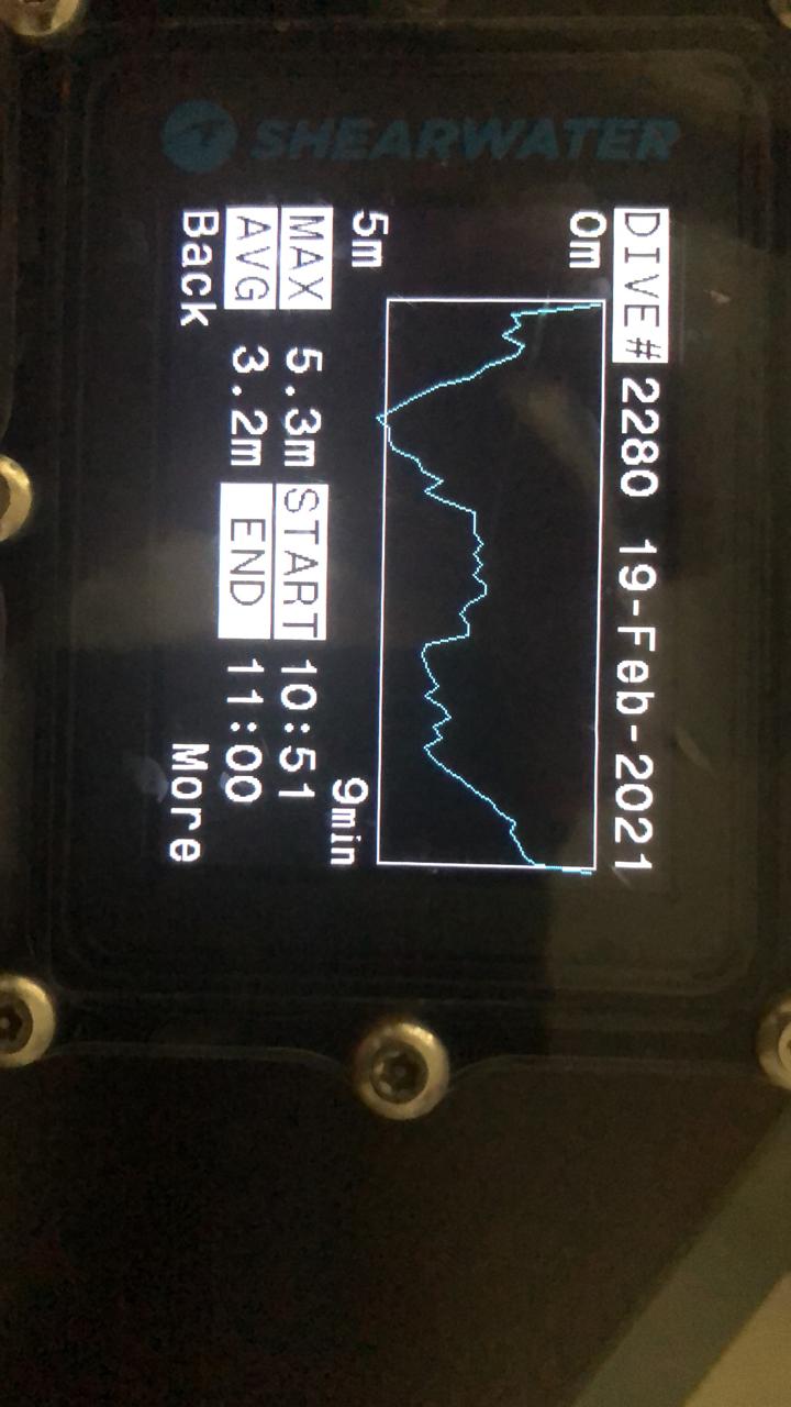
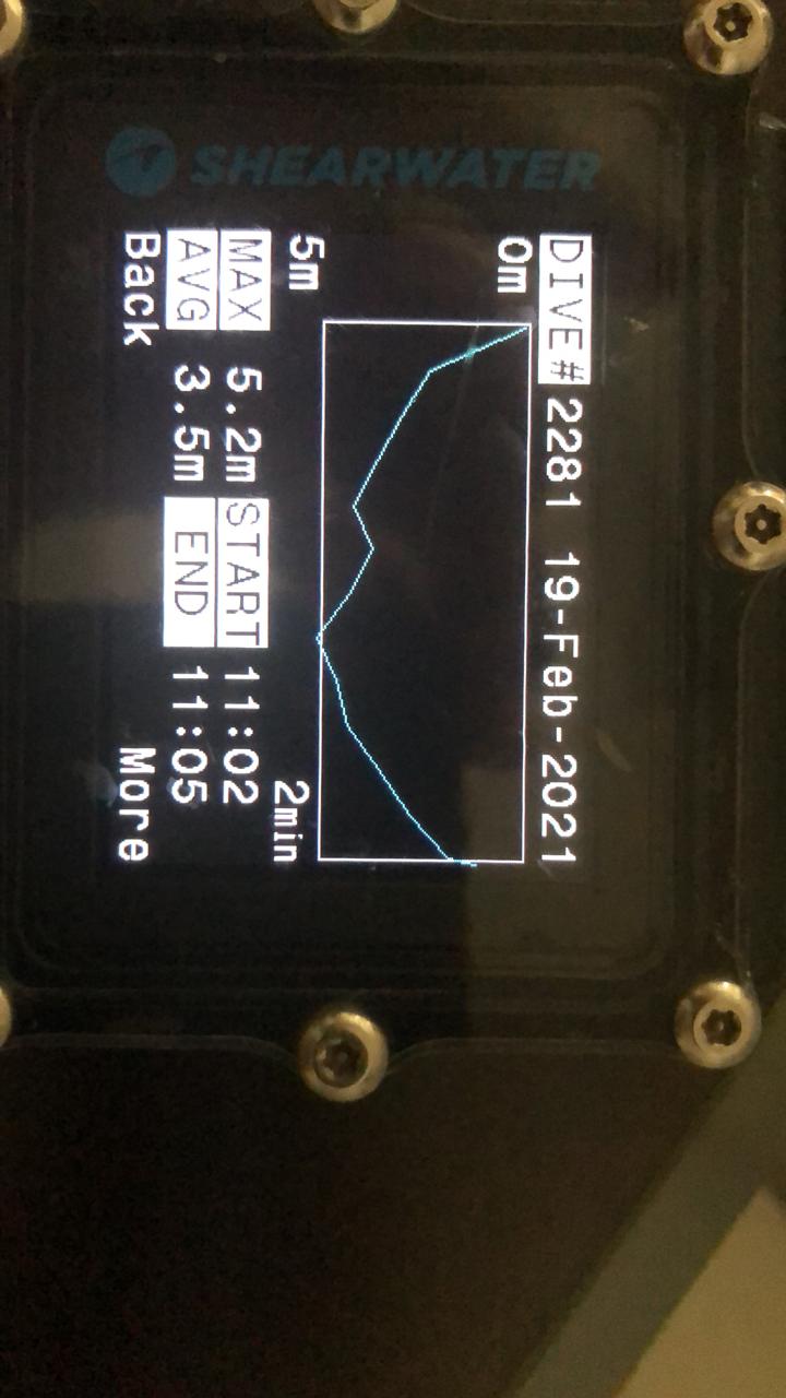
Depth - At its deepest point, the Rangala Natural Point was 5.5m (18.2 ft) deep, (See maps below for more details). Near the waterfall, the depth was about 3m (10 ft). This is based on the water levels of the day (19th of February 2021). It is possible that the depths can be shallower in the dry season, and higher in the rainy season.
Temperature -
Surface 24°C
Bottom 20°C
Average Temperature (February 2021) 22°C
Can be warmer and colder depending on time of measurement.
These measurements were done between 1028 - 1105 HRS
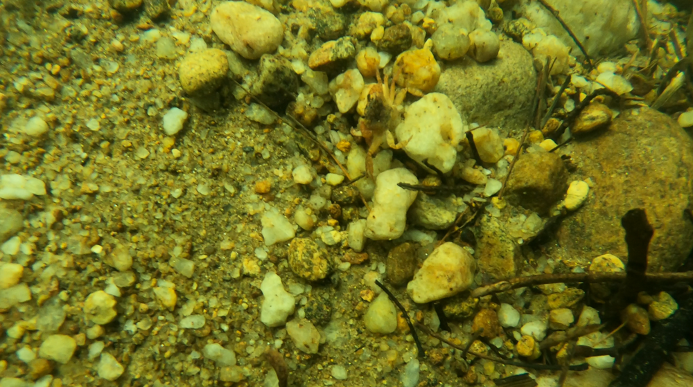
Composition - A sloping sand bank gradually leads to a depth of about 5.5m (18.2 ft) (depending on the water level of the day). The bottom is composed of a mixture of rocks and sand. The water visibility is very good. The bottom also contains detritus from trees including leaves and branches.
Some levels of pollution were noticed. These could be partly washed in from the Kota Ganga river, and partly waste left by visitors
Aquatic Life - Crabs of various sizes and several species of freshwater fish were observed. This is a thriving natural eco system.
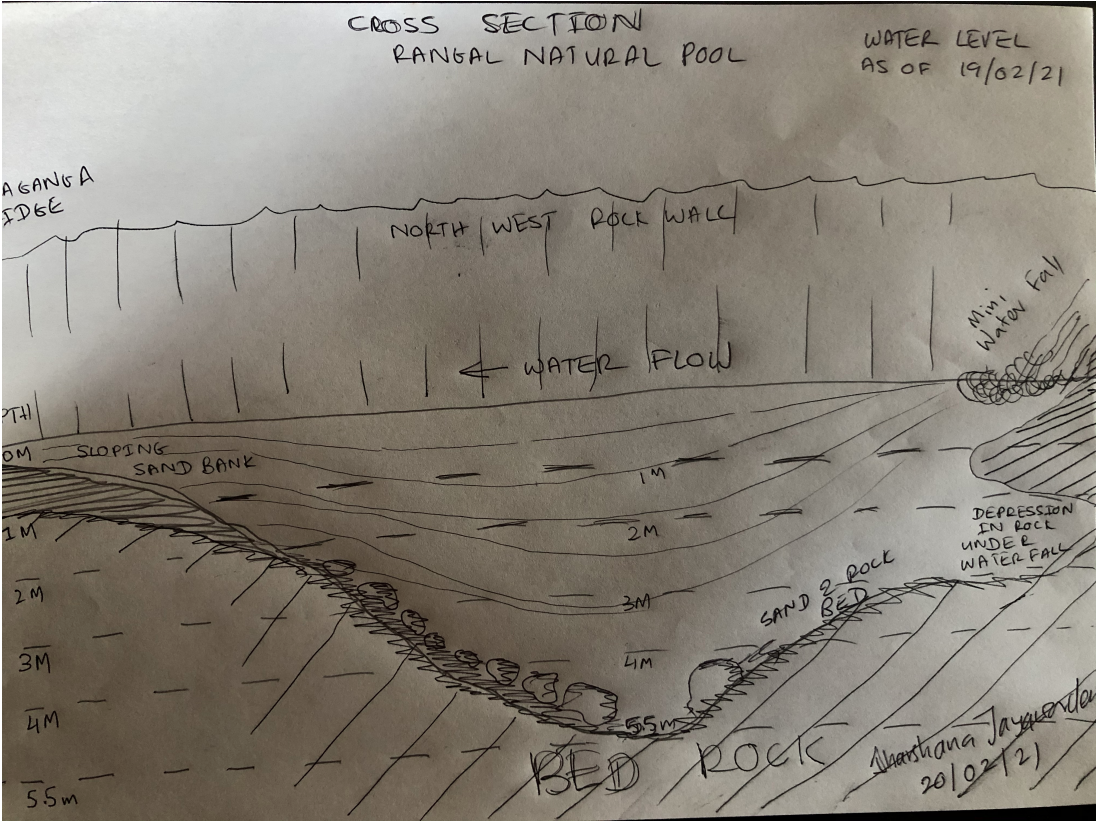
Cross Section: Faces North West. Kota Ganga Bridge is on the left and the waterfall to the right. Water flows from Right to Left.
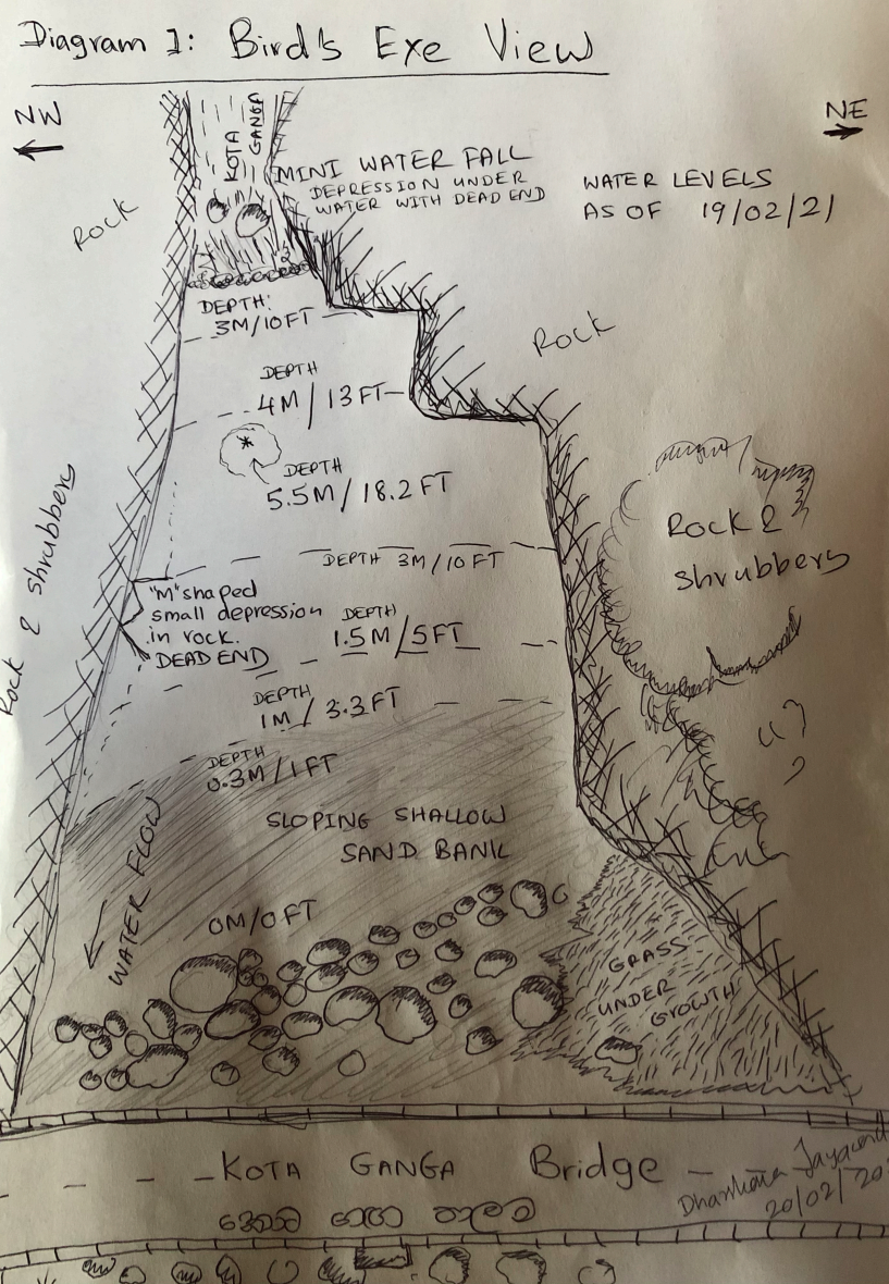
Birds Eye View: The Kota Ganga bridge is at the bottom and the mini water-fall on the top of this image.
During the survey, the divers carefully inspected the walls of the Rangala Natural Pool inch by inch. No entrances to underwater caves or tunnels exist. During the dive one villager informed the divers that there is a tunnel and pointed to a location. Upon inspection, it was verified that it is merely a small depression in the rock (‘M’ shaped depression marked in the ‘Birds Eye View’ map) and a dead end. Under the water fall there is a depression into the rock, but again it's a dead end and a natural creation, probably carved by flow of water for thousands of years.
The divers can attest that, Rangala Natural Pool is a natural creation and no artificial constructions were sighted.
Video footage obtained during these dives have been provided to OIC IP Ranga Jeewa.

The Rangala Natural Pool constitutes several kinds of dangers to human life.
Depth :The pool looks deceptively beautiful and harmless. A non-swimmer can very easily drown as soon as the person wanders away from the sand bank. To date, several swimmers have lost their life.
Temperature :The temperature variance of 20°C - 24°C, with an average temperature of 22C (As measured during 1028 - 1105 HRS on 19th of February 2021). This temperature can induce hypothermia, including numbness and disorientation, with prolonged exposure, and can add to a panic situation of a non-swimmer out-of-depth.
Slippery and unstable rocks :To access the pool, a swimmer must walk over slippery and unstable rocks. If care is not taken, it is very easy to sustain serious bodily or head injuries.
Broken Glass :Broken glass bottles can be found around the sand bank and pose a danger to swimmers
It is well known that intoxicated travellers access the pool, therefore that group is at most risk due to a combination of above dangers.
The Rangala Natural Pool yet remains a pristine eco system with minimal pollution. Various species of aquatic life thrive in this environment. Access by the general public, specially in large volumes can seriously damage or destroy this habitat because of overuse and pollution.
In light of the above considerations highlighting harm to human life and natural environment, it is the author’s opinion that the Rangala Natural Pool should be closed to the General Public, prohibiting swimming.
The area of the river, detailed in the ‘Birds Eye View’ map can be declared as a restricted area, helping to prevent accidents and damage to the sensitive ecology of the pool.

The author wishes to acknowledge help of the Sri Lanka Police in this exploration.
SSP Jagath Seram, and OIC of the Rangala Police Station, IP Rangajeeva Rajapakse for approving and facilitating this exploration.
SI Welagedara of the Police Life Saving Unit for being on standby at the Rangala Natural Pool for any emergency.